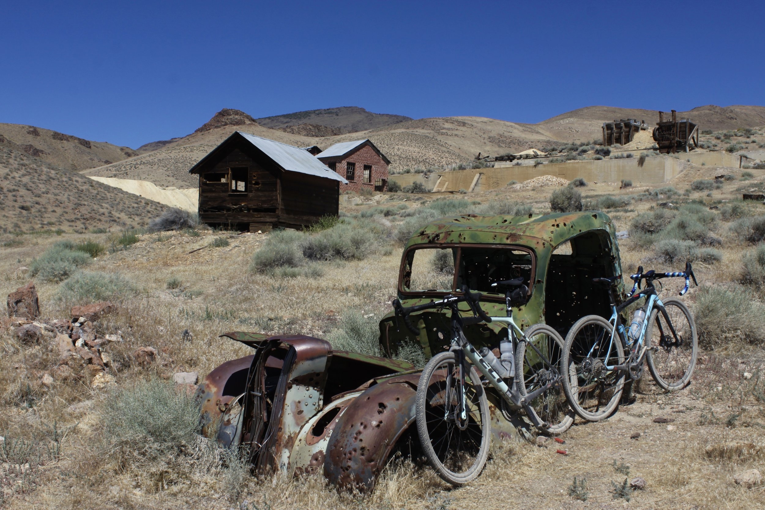
Tunnel Camp - Remnants left behind.
This is a fantastic Gravel Bike, or Mountain Bike outing. The road out to Tunnel Camp is nice and smooth and suits a Gravel Bike well.

Small underground barracks.

The main Office Building of Tunnel Camp.
Tunnel Camp is located in the Seven Troughs Mountain Range west of Lovelock, Nv., just north of Hwy 399 which terminates at the Eagle Pichr Mine. This mining district was ravaged with a series of unfortunate events. The town of Mazuma was first established in 1907. It was the central hub of this district, and this town supported Fairview Mine, Seven Troughs Mine, and Portland Mine, all of which were chasing gold ore. The main problem that they encountered was prolific ground water. Once the mines got down to the water table, they ended up releasing some of the ground pressure on the water table, and the water in the mines began to rise. This cut off access to the gold ore veins. Because of the water problem, L.A. Friedman began buying up many of the flooded mines in the area, and constructed the town of Tunnel Camp on the eastern flanks of the Seven Troughs Mountain Range. He had the idea of digging a “Tunnel” two miles through the mountain range to drain water from the flooded mines. This Tunnel could also be used to move ore from one side of the range to the other, then have the ore crushed, processed and separated in huge cyanide leach ponds. Mr. Friedman managed to find $30 million investment dollars to dig the “Deep Tunnel” through the mountain. Due to mis calculation, the “Deep Tunnel” ended up 500 to 700 feet above the water level of the mines on the western slope of the range. At almost the same time, July 18, 1912, there was a torrential rain storm that hit the mountain range. Above the town of Mazuma is where most of the ore processing was taking place for the mines. When the deluge of rain hit the canyon, a wall of water washed away all the cyanide tanks carrying the water and cyanide thundering down the canyon toward the town of Mazuma. This 20 foot tall wave of water ended up washing most of the town down the canyon and into the valley below, killing 8 residents. Most of the residents were working in the mine when the tragedy occurred, saving many lives. However, due to the “Deep Tunnel” being unsuccessful, and Monzuma being washed away, this mostly ended the mining in this district.
For this ride, copy and paste this link into Google Maps, then you can send the location to your phone, and just follow it. (Start for Tunnel Camp Ride)
Here is the Strava Link for the ride (Tunnel Camp Gravel Ride)


Old “5-Stamp” mill. Ore was loaded above and behind the stamp mill, and as the ore traveled down it was hammered or “Stamped” into smaller pieces. There are 5 stamps on this mill. The ore was then taken below to the cyanide ponds for gold separation.
from Reno, Nv. take I-80 east towards Lovelock. Take your first exit onto Cornell Avenue, take a left on Main St, then a right on Central Ave, St Rte 398. Take Central Ave and turn left on Rte 399. Follow Rte 399 for just over 12 miles, and you will see the one and only large dirt road on your left. This is the start for the ride. Park here, and start riding north-west on this road. In 4.7 miles you will come to a “Y” intersection. Stay left. Continue on the left fork for 3.5 miles, and you will come to another “Y” intersection. Stay to the right which is more like going strait. If you go left, you will end up at the old town side of Vernon. There is nothing left to see here. The buildings that used to be here were moved to Tunnel Camp as the new town was being build. From this intersection, you can see the town of Tunnel Camp at the base of the mountain range to your left. Just visually follow the road in front of you, and you can see a dirt road cutting hard left and heading up to Tunnel Camp. Continue on the dirt road for another 1.8 miles, and you come to another “Y” in the road. Take a left, and this road takes you right into the center of Tunnel Camp. If you continue strait, this will take you to Monzuma and to the mines above Monzuma. I have not been there yet, but plan on it in the near future. So this blog might change. However, take a left, the road gets a little rougher, but not bad. Continue for another .75 miles and you will be in Tunnel Camp. There are a couple side roads, but you can see your destination, and all roads take you to Tunnel Camp. Now go explore, and when you are done, just retrace your steps back home.
