

Nobles Cave and my trusty steed.
History - Lassen Applegate Trail, and Nobles Trail, late 1800s


With the great Gold Rush heading to California in the late 1800’s, emigrants flooded Northern Nevada in some of the harshest environments imaginable. As the wagon trains traveled cross country, 15 miles / day was an average day, 20 was a fantastic day, and 3-5 miles /day was a horrible day. One of the main routes was the Applegate - Lassen Trail. Once the emigrants reached Winnemucca they would drop to the North end of Rye Patch (now Rye Patch Reservoir) near Lovelock, then they cut West to Rabbit Hole Spring and hope that there was water in this tiny spring, and is very near what is now a gold mine at Sulphur, then on to the East side of the Black Rock Desert. This stretch was around 100 miles to get from Winnemucca to the Black Rock Desert and would take 7-8 days. Rabbit Hole Spring would turn into a disaster as more people pushed for California. The spring is just a tiny spring and can’t support much traffic. The Emigrants dug out the spring so that more water could pool for future wagon trains. The main issue, is that there was little to no water from Rye Patch to Rabbit Hole Spring. As livestock would near the spring, they could smell the water and would more or less stampede for the water. Many times there were just muddy patches with no water, and the livestock would just collapse and die. The Emigrants also in dire straits would try to push for Black Rock Hot Spring with no more water. Many emigrants reached Rabbit Hole Springs only to find dead livestock dead in the spring which contaminated the water. Once they reached Double Hot Hot Springs at Black Rock Point, which is North of Gerlach, they would find salt grass, and drinkable water further away from the spring. The emigrants would then follow the Western leg of the Black Rock Desert North-West to Soldier Meadows. They would have water and grass for the livestock for this section of travel. Once rested at Soldier Meadows, the Lassen Applegate Trail went west up Fly Canyon to High Rock Lake. This was one of those 3 mile days where they had to disassemble their wagons and use ropes and pullies to lift the wagons up the steep canyon walls. Once at High Rock Lake, the Trail continued up High Rock Canyon which is full of water and grass. Then the trail would mellow to Lassen, California. Because this trip was so difficult, a new trail called the Nobles Trail was discovered by William Nobles in 1852. This trail was much easier, and quickly became the “Trail to use” by the emigrants. Once the emigrants reached Rabbit Hole Spring, they would turn due South to Trego Hot Spring which had much more water than Rabbit Hole Spring. Then they would cross the Black Rock Desert Playa to Granite Spring, then turn South to what is now Gerlach. This route was smoother, faster, and more available water and grass. Once at Gerlach they would follow the Nobles trail West to the North end of the Smoke Creek Desert, then across to Smoke Creek. At the head of Smoke Creek, there is a giant spring that feeds Smoke Creek year round, so once at the mouth of Smoke Creek, they would have grass and water all the way up the canyon.
The Ride

Smith Creek

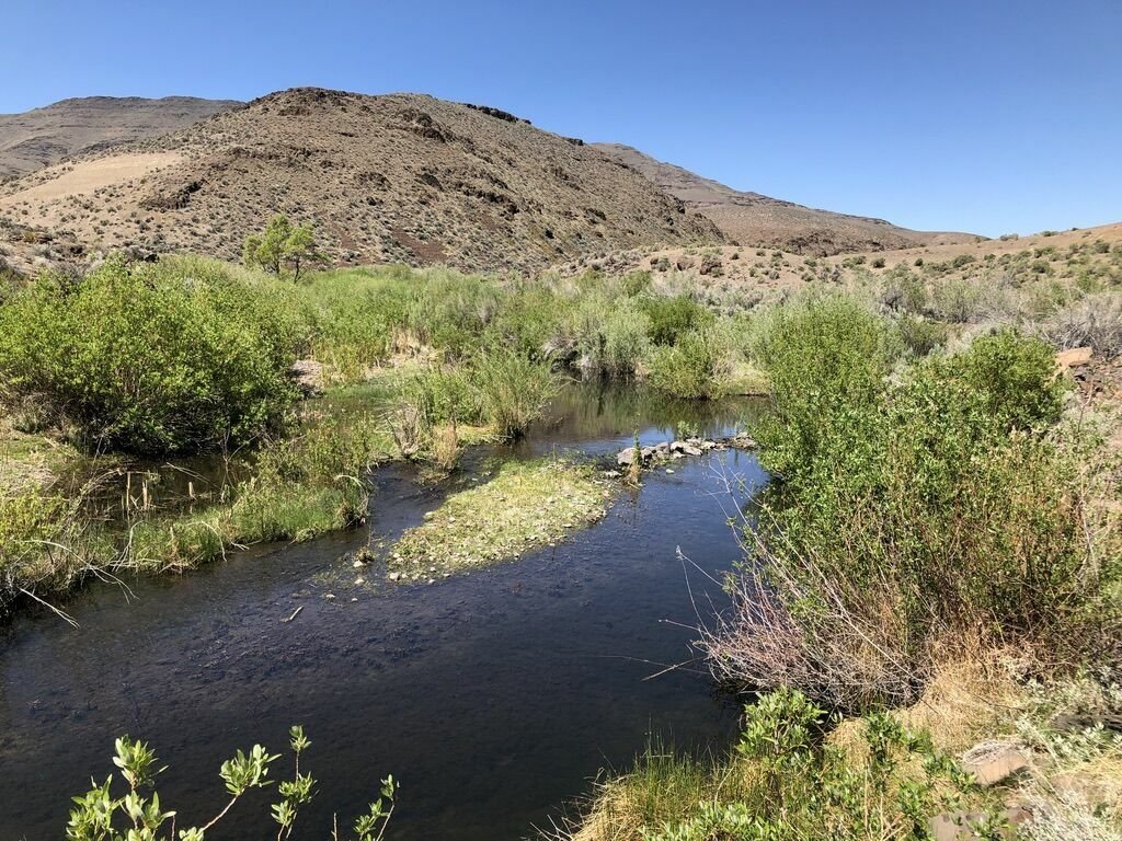
The meadow where Rush Creek and Smoke Creek come together
From Reno it is 82 miles to Smoke Creek Rd, the start of this ride. The easiest way to get there is to take Pyramid Hwy, 445 to Pyramid Lake then to Sutcliff. This is your last spot for any amenities. Continue North for 47.5 miles. Hwy 445 will remain pavement to the North end of Pyramid Lake, then it turns to dirt. It continues North up and over Sand Pass, and down into the Smoke Creek Desert. Here the road hugs the Eastern side of the playa and continues all the way to Smoke Creek Road. However, 32.8 miles from Sutcliff is a beautiful Hot Spring at the old Bonham Ranch, Flowing Wells Hot Spring. The spring is past the pools that you see on the right, and the hot spring is on the right or East side of the road. Continue to the start of the ride at Smoke Creek Road. Right before you get to Smoke Creek Road, you will cross Smoke Creek. After driving down this beautifully smooth dusty dirt road, you will be amazed to see how much water is flowing in Smoke Creek that just runs out onto the playa, and disappears. Just up the hill from the creek crossing is Smoke Creek Road on your left. Park here. Load up on the bikes, and head left, West up Smoke Creek road. The first part of the road is well away from the creek, but in 3 miles, the road will hit the mouth of the canyon with the creek on your left. You are now on Nobles Trail heading up the canyon. At 4 miles from the car, you will arrive at Nobles Cave where the emigrants would rest inside the shelter of the cave. It is big enough do drive a suv into. Continue up the canyon and admire the cliff faces. There are a couple Golden Eagles nesting in the rocks 5.5ish miles from the car. As you look at the rocks, you will start to see Tufa Domes on much of the rock. Tufa is formed when water splashes on the rocks, the water evaporates leaving a calcium carbonate solid behind. This was all part of the Great Lake Lahontan well over 10,000 years ago. This Great inland lake extended from The Great Salt Lake of Utah all the way across Nevada, and you are in it’s Northern most region that also included The Black Rock Desert extending a little further North that than. Anyway, recognize how much climbing you have done from the Smoke Creek Desert playa to the tip of the tufa deposits. That is how far underwater you would have been. Anyway, continue up the canyon, and at 8 miles from the car, the canyon will open up into a giant grassy meadow where Rush Creek and Smoke Creek come together. At 11 miles from the car you will hit an intersection. When I rode this ride, the gate going strait up the canyon was open, and there were no signs on the gate to say “No Trespassing.” However, I found out this is s private road. So, turn left, cross the meadow, an climb up out of the meadow. This is still the Nobles Trail. When you crest the ridge, you will come to another Historic Marker telling you that the Nobles trail was down in the canyon of Rush Creek. From here, continue West up the road. It gradually climbs for miles. You will cross over Rush Creek, and in 15.2 miles from the car, you will see Rush Creek go up the canyon to your right, and a light dirt road to your right. You will see an old cabin in the small grove of trees where the settlers would stop. From here the trail continues west more or less following the road. This road will eventually drop you off on Hwy 395, a couple miles South of Susanville. At this point, it is only up to you, and how many miles you want to ride. So ride as far as you want, turn around and retrace your steps back to the car. And remember the hot spring on your way home.

Rush Creek


When accessing the Ride With GPS link below, there is a drop down menu on the upper right of the map. This drop down menu allows you to change the kind of map you are looking at, from a Google Satellite map to a USGS Topo man, and any other map inbetween.
Here is the BLM ERSI map for the entire Nobles Trail.